R.C. Maher Originally 10/19/2002, with updates on 6/5/2006, 6/10/2007, 1/19/2009, 1/2/2012, 7/15/2020, 6/15/2021, and 7/6/2021.
NOTE: this is an informal description of my experience, not an authoritative document. Hike at your own risk, and Do not rely on this information, as trail conditions, wildlife activity, and acceptable use rules are subject to change at any time. Use your own judgment and common sense, hike safely, and always follow leave no trace principles.
Over the years I have visited the summit of Mt. Ellis (8331') via several different approaches and at several times of the year.
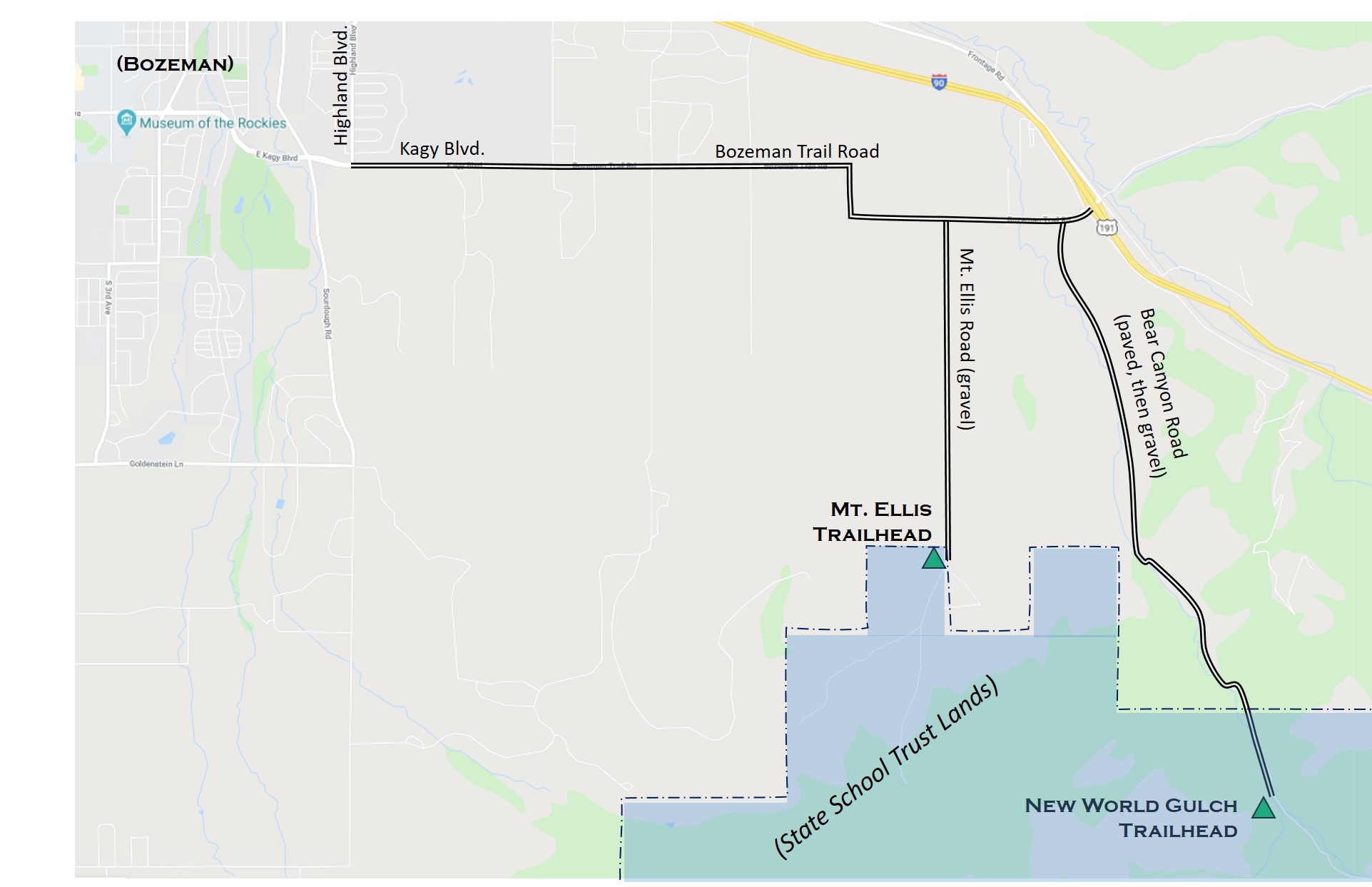
The two primary access points to Mt. Ellis are the trailhead at the south end of Mt. Ellis Road and the trailhead at New World Gulch in Bear Canyon. Starting in southeast Bozeman, proceed east on Kagy Blvd and continue out of town as the route becomes Bozeman Trail Road. Look for the Mt. Ellis Road as the first right turn after the big right-left corners on Bozeman Trail, or for Bear Canyon Road as the right turn shortly before coming to I-90. There is also an option (not recommended) of hiking up from Sourdough Canyon (see below).
NOTE that both of the primary trailheads are on Montana State School Trust Lands. There is a sign indicating that access to the National Forest land is allowed using the New World Gulch trail only: off-trail use requires a Montana State Lands Recreational Permit ($10), available from Montana Fish, Wildlife and Parks (FWP) offices and from outlets that sell fishing licenses. If you have a regular Montana hunting or fishing license, my understanding is that those licences already include the state lands access, so no additional permit is required.
NOTE that there is no reliable water sources on the routes from the Mt. Ellis Road trailhead, so plan accordingly if you bring your dog. In the spring there are sometimes puddles and trickles along the trail up onto the east side of Little Ellis, and there is a spring halfway along the Limestone Creek approach, but don't count on water. The New World Gulch approach has creek water near the start, but no water after leaving the creek valley.
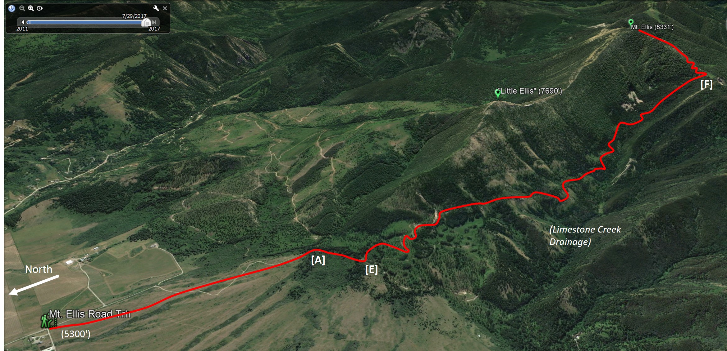
From the increasingly busy Mt. Ellis Trailhead, proceed through the gate--closing it behind you!--head south on the designated trail up through the large meadow. The meadow is an excellent place to see wildflowers in the spring and early summer. In the winter it is a popular cross country ski and snowshoe site. Stay on the meadow trail for 1 mile, all the way up to the point that it enters the edge of the trees (see [A] in Fig. 1).
Figure 1:
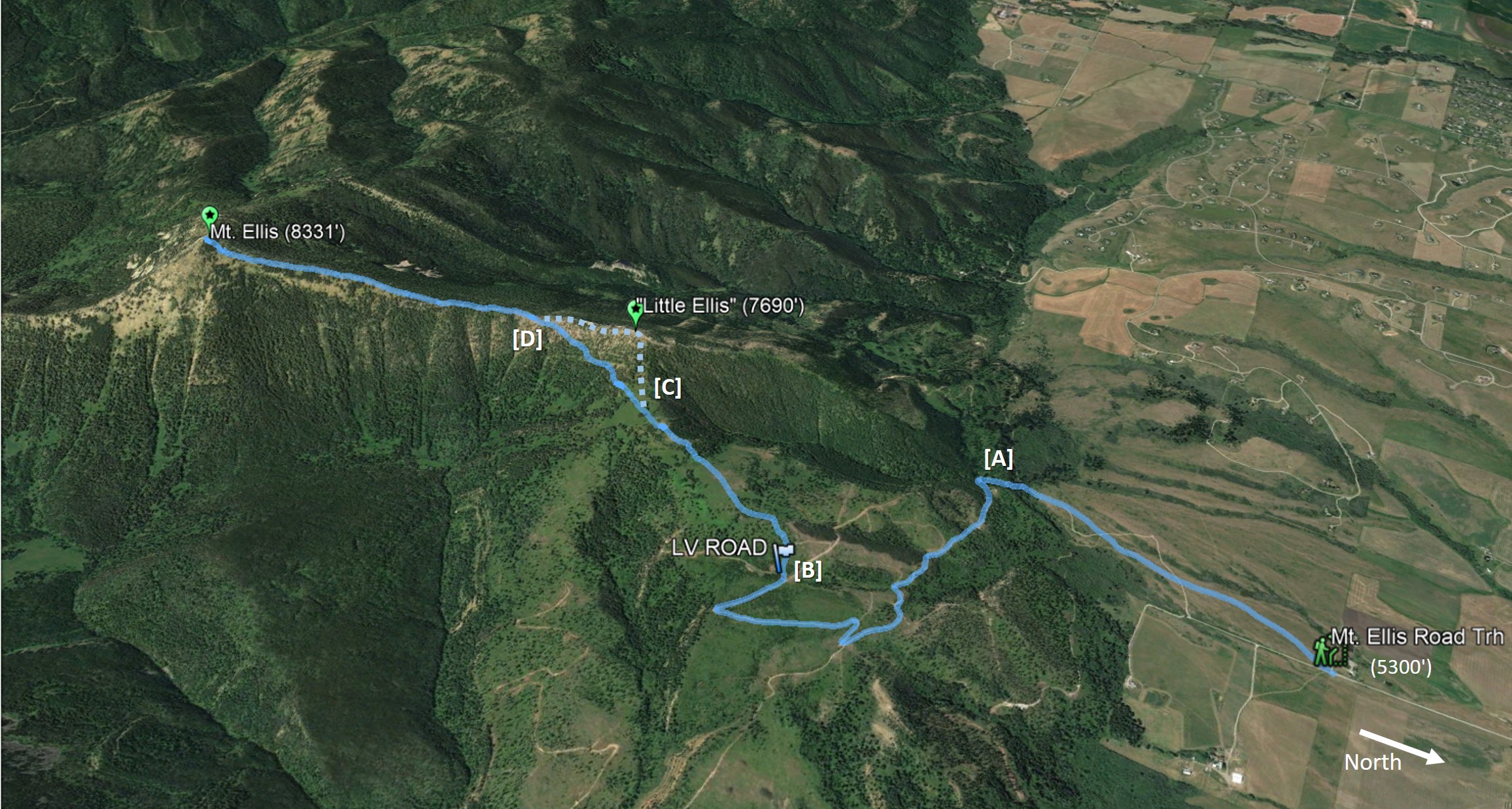
Description (Fig. 1): From the entry into the trees [A], the conventional route takes the old logging road south (straight) and then up as it contours east along the steepening slope. Continue on the road as it eventually climbs out of the valley and up onto the broad east-facing meadow. Stay on the "road" as it proceeds south and switches back to the north. When the road returns north and begins a second large switchback, look for the trail [B] that leaves the road heading west up the slope through the tall grass and shrubs. Stay on the trail up through the meadows, and through a nicely shaded section of trees. Beyond the trees as the trail tops out in a grassy meadow [C], either continue on the main trail up to the Little Ellis summit, or angle left and do an ascending traverse toward the trees to pick up the bypass trail over to the Mt. Ellis Ridge. From either Little Ellis or the bypass trail, arrive at the low point [D] on the main north ridge of Mt. Ellis. From there, the trail ascends the long ridge line, sometimes bypassing rock outcrops by moving to the west side. Remember to look back over your shoulder for a great view of the Gallatin Valley. After enjoying the summit, return back the same way. Elevation gain is about 3030', round trip distance about 10.5 miles, or a bit farther if you go over Little Ellis.
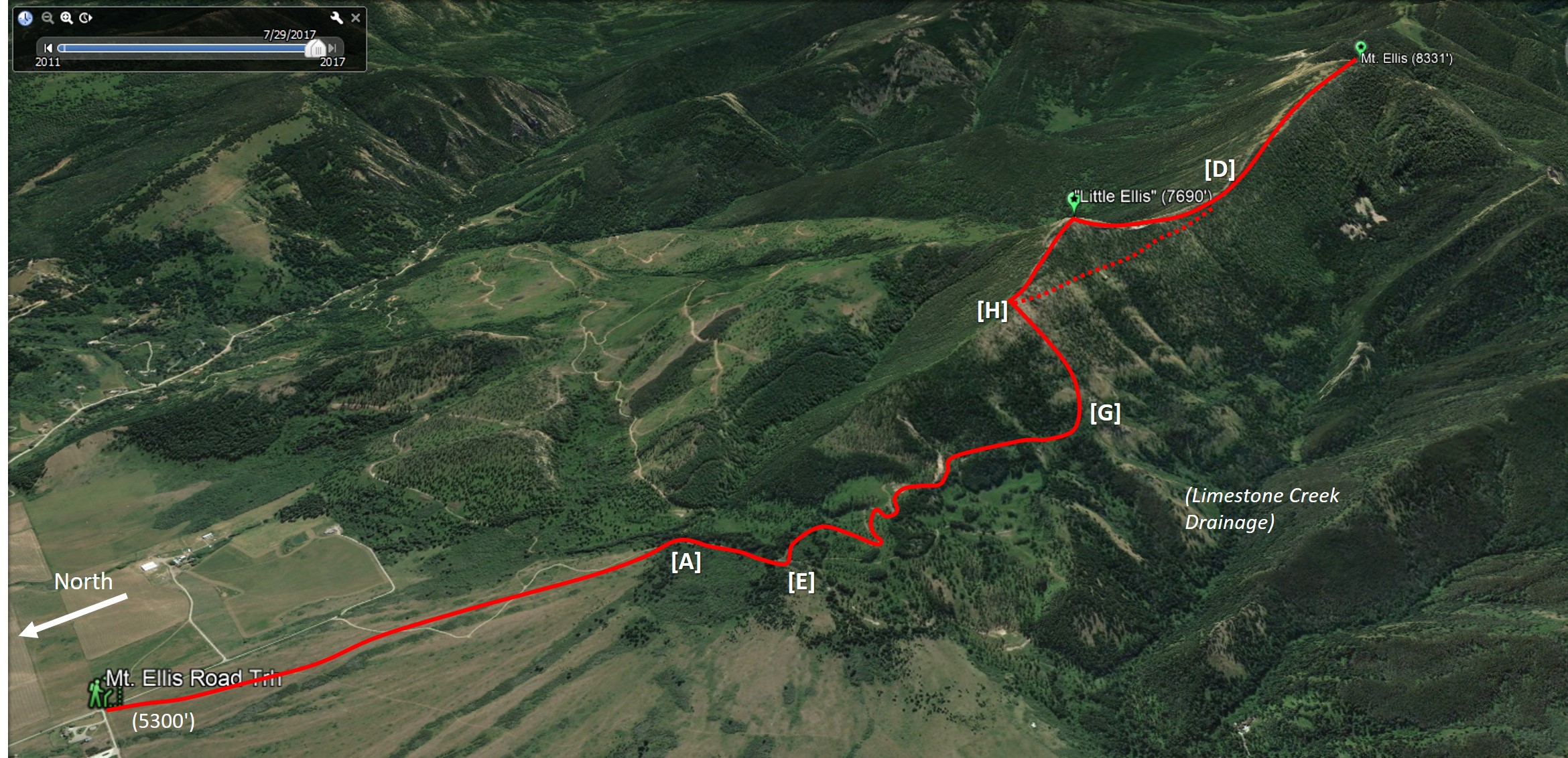
Figure 2:
Description (Fig. 2): For a more difficult route but with more variety, from the entry into the trees [A], the Limestone Creek approach takes the old logging road west (right) as it heads up along the edge of the forest. At the top of the first rise on the road [E], continue left (south) on the trail as it crosses and switchbacks up the recently-logged area. Follow the trail up the slopes and eventually into the trees above the divide with the Limestone Creek drainage. From there, the trail continues up on the east side of the Limestone valley, giving occasional views back down toward Bozeman and up toward Mt. Ellis. The trail passes a pair of buried barrels forming a watering spring for horses, then starts a steeper rise up through the trees at the head of the drainage. The trail steepens, and eventually reaches the ridge line [F] to the west of the Mt. Ellis summit, with views down into the Sourdough/Bozeman Creek drainage. From there, getting to the summit of Mt. Ellis currently involves no trail, with steep bushwhacking up the very steep shoulder of the west ridge, skirting more to the left (north) to get around obstacles on the route to the summit. From there, you can descend back the same way, or descend via the regular north ridge route. Elevation gain is about 3030', one-way distance to Mt. Ellis is about 5 miles.
Figure 3:
Description (Fig. 3): For the very adventuresome, here are some examples of more variety that are NOT RECOMMENDED. It is possible to do super steep bushwhacking by leaving the Limestone Creek route at the point [G] where the main trail starts to drop closer to the creek valley. At that point, ascend the very steep grassy meadow to reach the open ridge line [H] below and north of Little Ellis, and scramble from there to the top. A further variation from [H] is to bushwhack (carefully, so easy to slip and fall way down the slope!) across the lower west slopes of Little Ellis to reach the low point [D] of Mt. Ellis' north ridge. Neither of these variations is for casual hiking.
Figure 4:
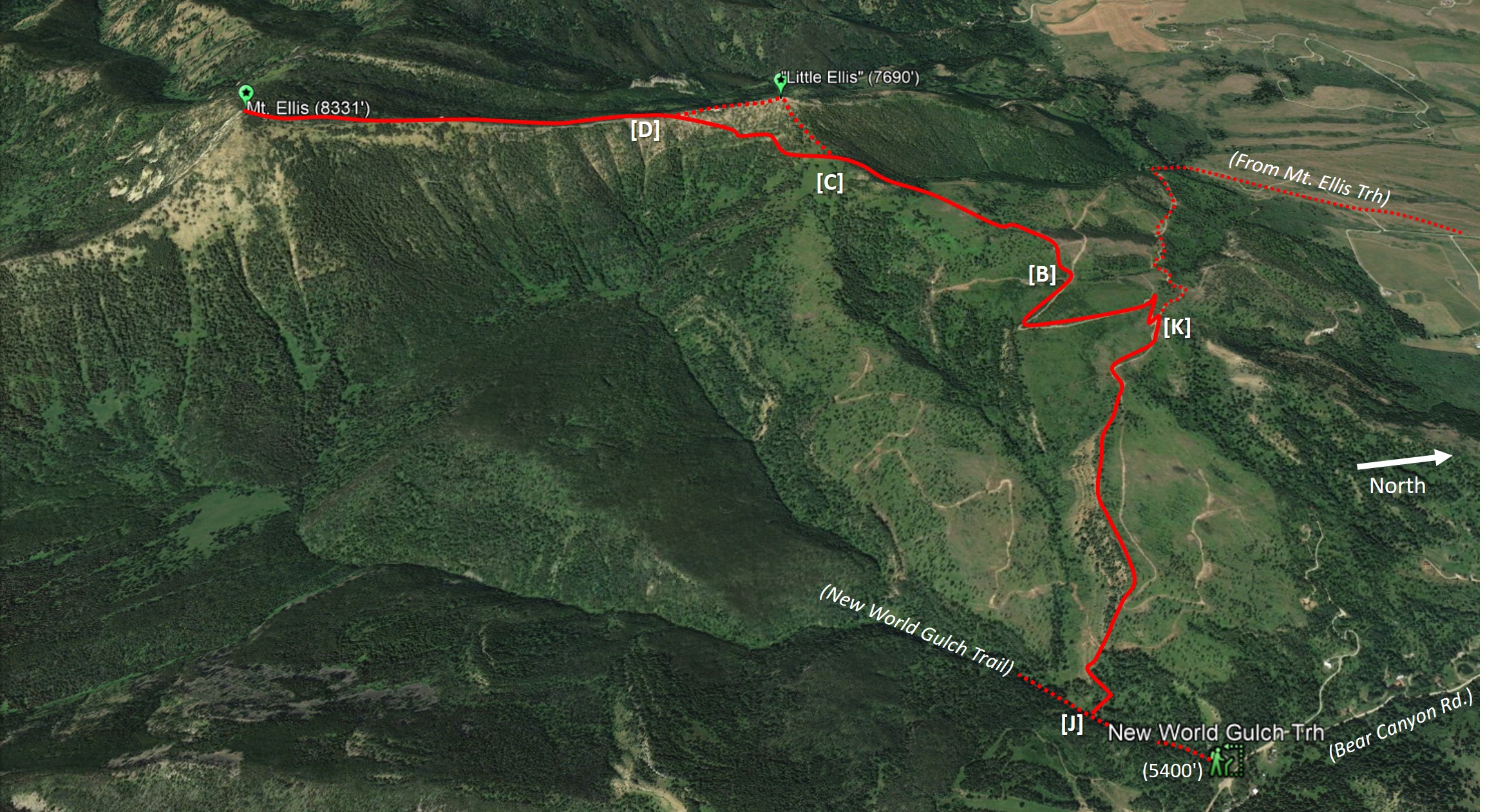
Description (Fig. 4): At the New World Gulch Trailhead near the south end of Bear Canyon Road, start up the trail for just 0.3 miles until the edge of the first clearing [J], then look carefully for signs of the small and easy-to-miss trail through the grass to the right. Cross the creek, and follow the STEEP and relentless trail up, up, up, onto the east-facing shoulder below Little Ellis. Join a logging road. Continue on that road to a junction [K] where this route joins the conventional route from Mt. Ellis trailhead. Continue up the switchback road to [B] where the trail leaves the road and heads up toward Little Ellis. Like the conventional route, there is a choice at [C] between staying on the main trail up over the summit of Little Ellis, or using the bypass trail. Either way, at the low point [D] on the north ridge, head up to Mt. Ellis. Return back the same way.
Figure 5:
Description (Fig. 5): For those who like challenges and extra exertion, there are several alternative connections and variations that are NOT RECOMMENDED.
One choice is to ascend Mt. Ellis via the northeast trail (dotted red in Fig. 5), but instead of turning around on the summit and heading back down the way you came up, instead proceed southeast off the summit of Mt. Ellis and bushwhack down the surprisingly narrow ridge top (solid blue in Fig. 5) descending south toward the Mystic Lake drainage. There does not appear to be an established trail, so staying near the ridge line seems to work. Watch out as the ridge meets a very abrupt cliff edge (!) about a mile south of the Mt. Ellis summit. After carefully skirting west on the ridge above the cliff section, descend left and bushwhack the steep slope in the trees [N] and look for a nice established horse trail that follows the descending ridge topography before eventually intersecting with the regular New World Gulch Trail [O]. The loop is 10.8 miles, with 3,031' total elevation gain.
Another variation that is not recommended is to use the New World Gulch Trail at first, but take the Moonshine Gulch Trail to the right [L] and continue up the narrow creek valley. When the Moonshine Trail turns south (left) [M], leave that trail and proceed down the small grassy slope and across the creek. Look up and head northwest up the draw by bushwhacking in the unmarked steep slope. Aim more or less directly at Little Ellis and chug up the very steep hillside for about half a mile and look for the intersection with the bypass trail just before the slope gets even more steep closer to Little Ellis. Again, this is not a recommended approach due to the steep and unmarked condition.
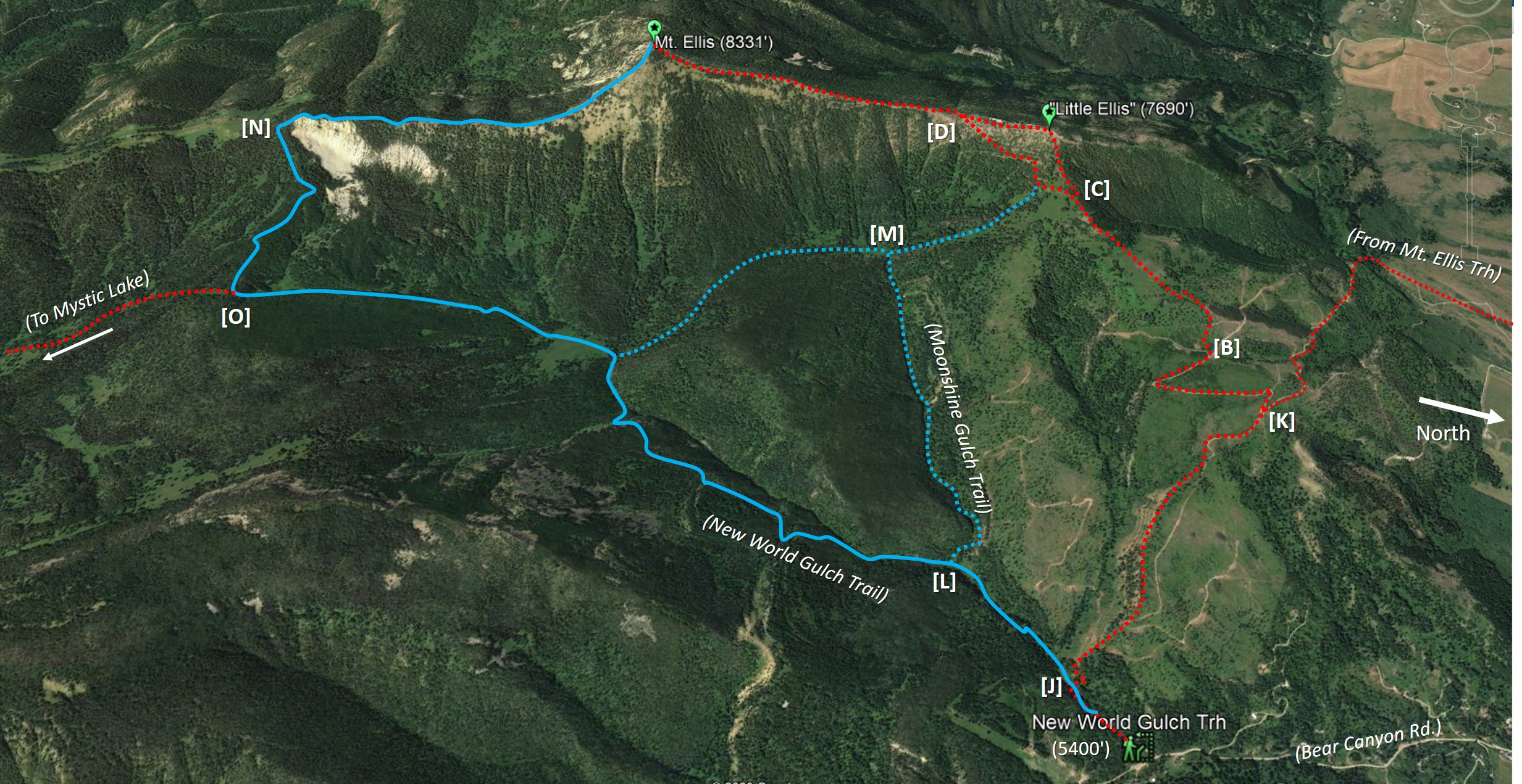
Figure 6: Loop with bushwhacking to Mystic Lake.
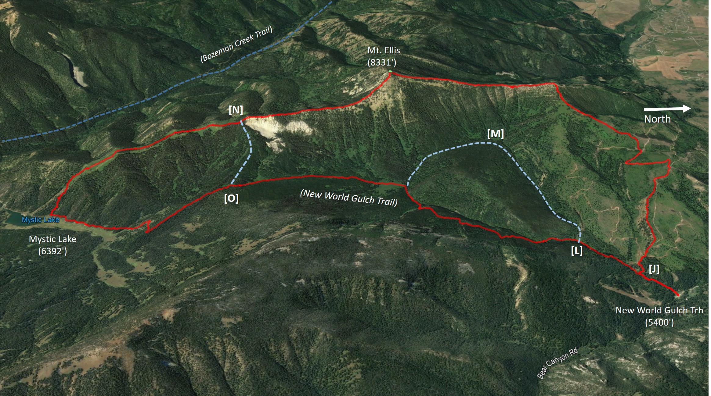
Description (Fig. 6): Follow the ascent to Mt. Ellis shown in Figure 4, then proceed along the southeast ridge (no trail) as in Figure 5. Watch out as the ridge meets a very abrupt cliff edge, carefully skirting west to [N], then continue down along the narrow clearing and frequently exposed limestone ridge and open, grassy meadow all the way south southwest to Mystic Lake. Join the regular Mystic Lake - New World Gulch trail (turn left) and loop back north to return to New World Gulch [O]. The roundtrip is about 13.8 miles, 3,814' total elevation gain.
Figure 7:
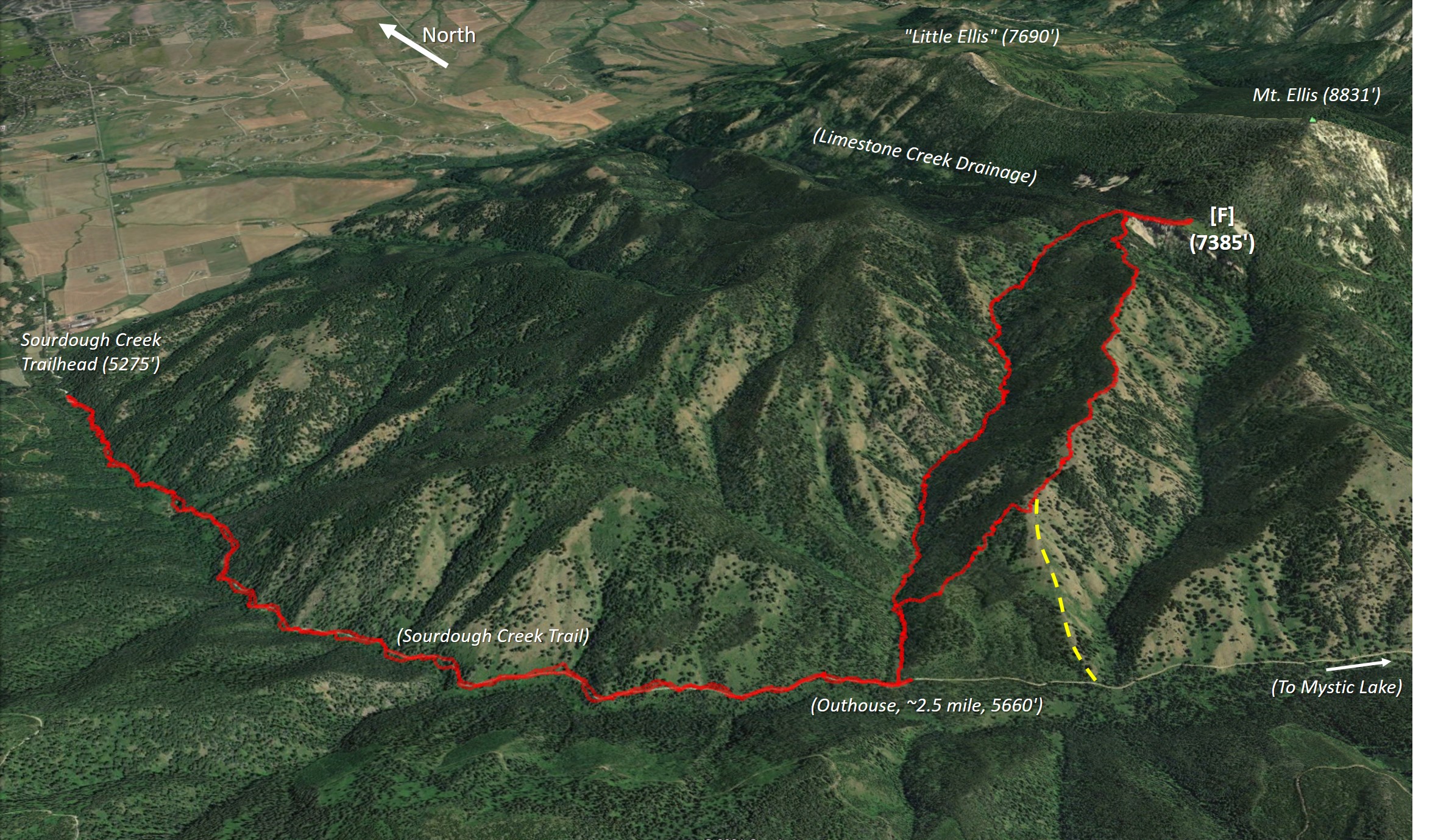
Description (Fig. 7): Starting at the Bozeman Creek / Sourdough Creek trailhead off Nash Road, proceed up the road/trail for about 2.5 miles to a wide point where there is an outhouse and head east up the draw on a weak game trail, OR continue to about 3 miles where there is a bit of clearing and visible ridge to the left (yellow dashed segment) and head east up the ridge. Stay pretty much on the relentless ridge up over various local high points and eventually reach a cliff band guarding the west approach. Skirt around to the north on grassy slopes, and arrive at the grassy meadow and ridge line [F] to the west of the Mt. Ellis summit. From there, steep bushwhacking up the very steep shoulder of the west ridge (no trail), skirting more to the left (north) to get around obstacles on the route to the summit. The roundtrip is about 12 miles, with about 3,560' elevation gain.
Original, October 2002:
I drove east on Kagy Blvd, and continued east when the road becomes Bozeman Trail all the way to Bear Canyon Road. Turned south on Bear Canyon, and proceeded 4 miles or so to reach the New World Gulch trailhead (about 5400', see map below). The trailhead is on Montana State School Trust Lands. There is a sign indicating that access to the National Forest land is allowed using the New World Gulch trail only: off-trail use requires a Montana State Lands Recreational Permit ($10), available from Montana Fish, Wildlife and Parks (FWP) offices and from outlets that sell fishing licenses. The National Forest boundary is the wide-dashed line indicated on the map below (click map to see larger version, 480kB).
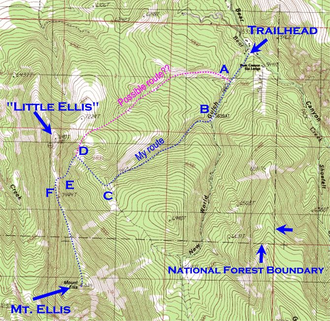
The New World Gulch trail heads southwest along the creek bottom and climbs gradually for about a mile to a creek crossing [B on map]. Shortly after the crossing the trail splits, with the south branch heading up New World Gulch and the west branch heading along a creek toward the north ridge of Mount Ellis. I took the west branch toward the ridge and continued following the well-defined trail southwest for another 1.5 miles or so. At this point the main trail reached a clearing then turned sharply to the south-southeast [C on map].
About 20 paces after the sharp turn in the main trail, I left the trail and proceeded west down a small grassy slope, crossed the creek, and headed northwest up the draw using a faint game trail and some bushwhacking. This route aims more or less directly at what I call "Little Ellis," the rocky summit at the north end of the Mt. Ellis ridge. The route up the draw also avoids eroding the steep and brushy slope on the east side of the ridge. I stayed on this route for about half a mile and reached a grassy clearing [D on map] just before the slope started its steep run up to Little Ellis. At this point I discovered and followed a distinct trail making an ascending traverse to the south in the direction of the low point on the Mt. Ellis -- Little Ellis ridge. The trail became faint at some points and eventually petered out. About 200 feet below the low point on the ridge, I found a steep and somewhat sandy groove [E on map] that allowed me to switchback up to the ridge line [F on map].
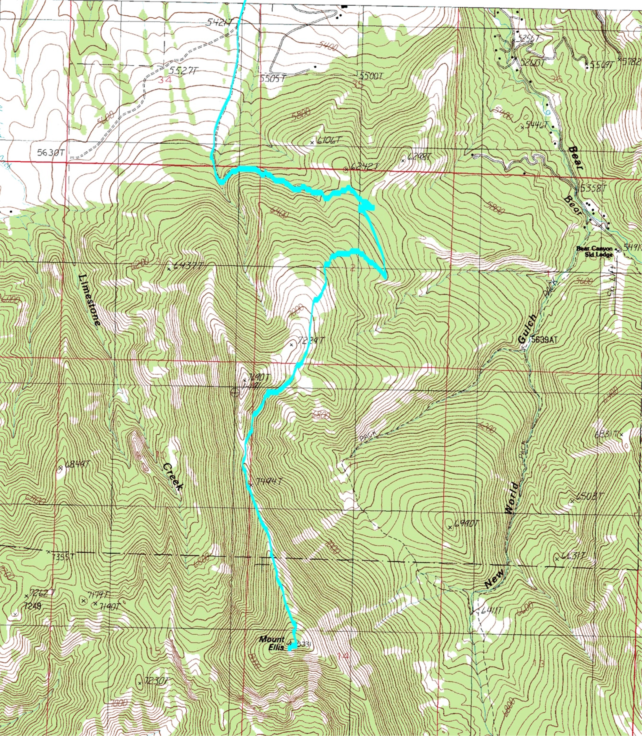
From the ridge a nice hiker's trail leads all the way to the top of Mt. Ellis. It skirts some rocky outcroppings by descending slightly to the west side of the ridge at a couple points. The summit of Mt. Ellis provides a great view to the west, south, and east. Views of Bozeman are best from the clearings partway up the north ridge.
I descended via the same route. Roundtrip from the trailhead to the summit took me 3h 45m.
Next time for some variety I will try a different approach [A on map] using the creek valley that enters New World Gulch from the west about half a mile from the trailhead. It appears from the map that this route should lead up to the clear area to the southeast of Little Ellis, and allow access to the same ridgeline--and also allow a direct option to the summit of Little Ellis along the way.
*An Update 2006:
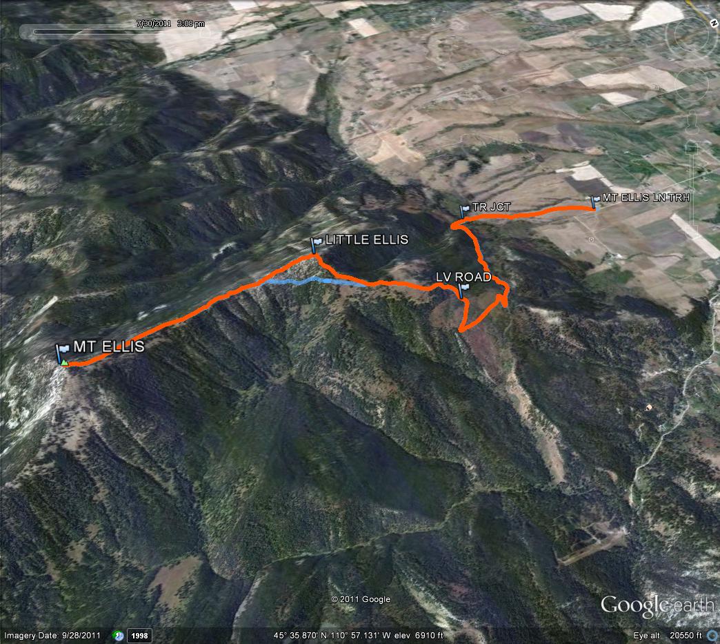
On June 6, 2006, I joined several colleagues in a hike to Mt. Ellis from the Mt. Ellis Lane trailhead. Mt. Ellis Lane heads south from Bozeman Trail Road one half mile east of where Bozeman Trail Road turns east after the zig-zag. We proceeded south on Mt. Ellis Lane 1.75 miles to a wide point at the State Lands access gate (southwest corner of the junction).
We followed the trail southwest through beautiful wild flowers and after about one mile entered the forested foothills. We followed the jeep road south and then curved around to the east and up through the forest and switchbacks. The road entered a large clearing and we continued on to the south and then around to the northwest as the road curved gradually up the hill. We left the road when it started to bend back to the south at elevation 6550', and instead followed a noticeable trail up the hill to the west and into the trees.
A few hundred feet farther along we broke out of the trees and started an ascending traverse across another clearing and around to the south west, aiming for the low point on the Mt. Ellis -- Little Ellis Ridge. The trail became indistinct at times and we did some bushwhacking on the steep slopes below Little Ellis, but eventually made it up to the ridge. From there we followed the nice hiker's trail to the summit.
On the descent we reached the low point on the ridge, then proceeded up over the top of Little Ellis. The views of south east Bozeman and the rest of the Gallatin Valley were tremendous. We followed the ridge north off Little Ellis, staying mostly in the clearings, and then descended steeply through the trees until we intersected one of the jeep roads. The road took us down to the original trail.
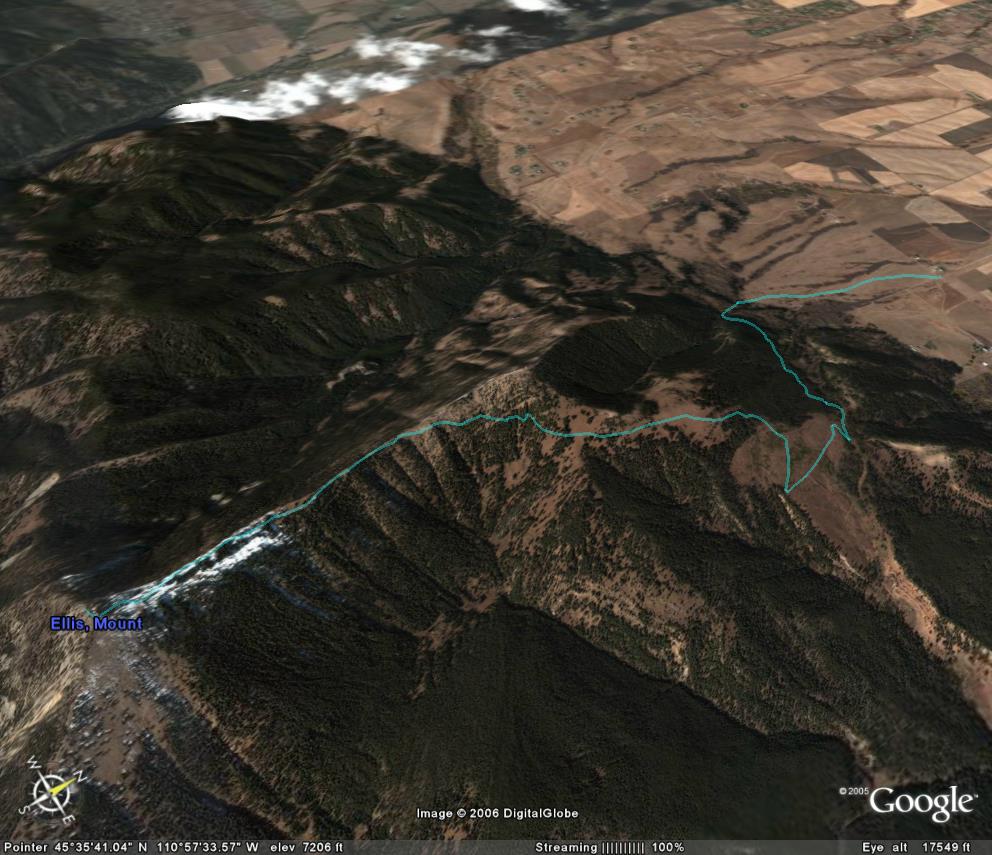
The ascent route is shown below. Click for the full-size image (2.09MB).
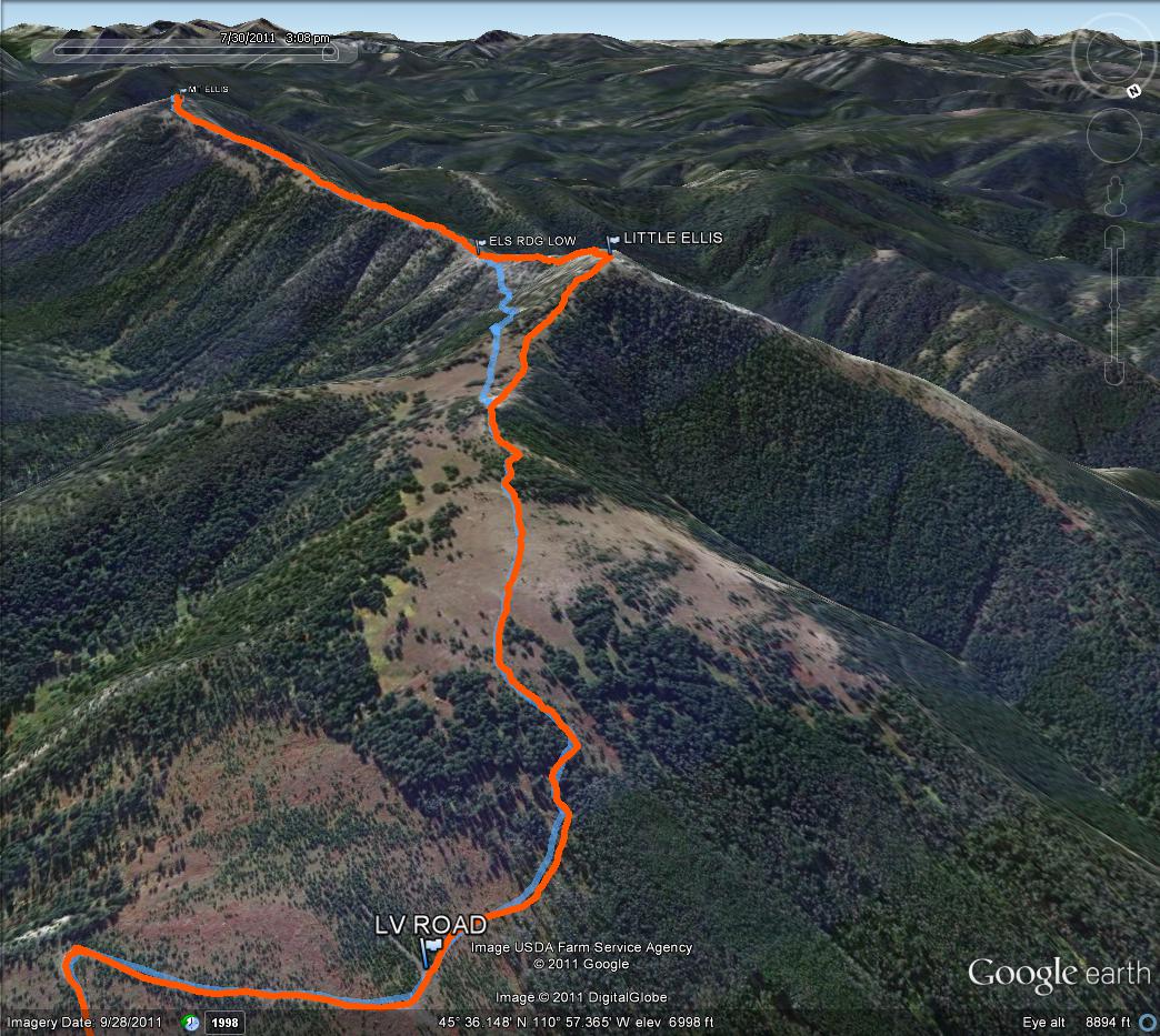
Here is the view of the ascent track from Google Earth. Click for the full-size image (134kB).
*An Update 2007:
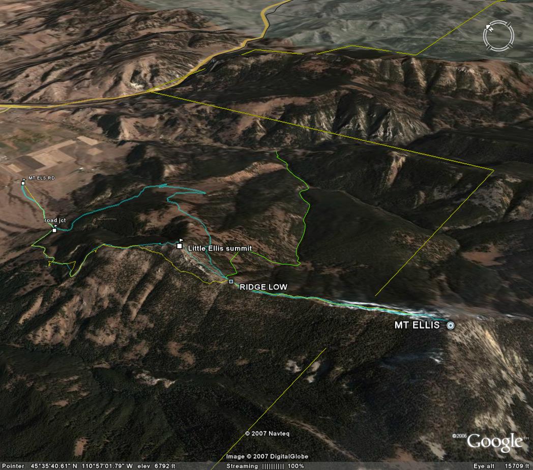
Then, on June 10, 2007, I used an alternate approach on the west side of Mt. Ellis, ascending Little Ellis via the northwest slope. On the descent I traversed north across the west face from the low point on the ridge, bypassing Little Ellis by bushwhacking, and then descended via the northwest slope. The Google Earth GPS tracks for all of the alternate routes (so far) are shown below. Click for the full-size image (170kB).
*An Update 2009:
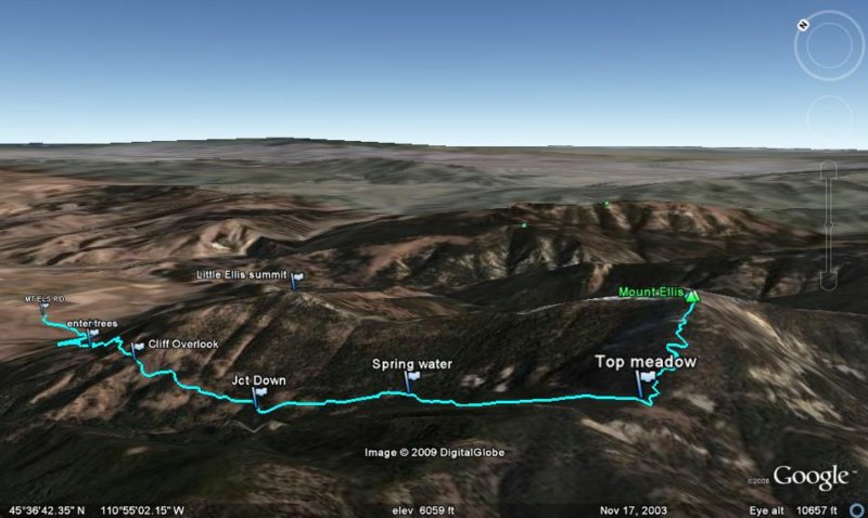
Since these trips I've routinely approached Mt. Ellis using a hiking/horse trail that runs south up Limestone Creek valley until it reaches Mt. Ellis' west ridge, then turned east toward the summit. Here is a Google Earth GPS track for the Limestone Creek approach,
And a photo album from January 19, 2009.
*An Update 2012:
The Mt. Ellis access from the north and east side has become more obvious in recent years due to a strong trail that has developed on the east ridge of Little Ellis. This trail appears to be a horse trail and it works OK for hiking--despite its steep pitch with essentially no switchbacks! I am hopeful that the erosion will not become a problem too quickly, although that remains to be seen.
Start at the Mt. Ellis Lane trailhead, and proceed on the trail south across the meadow to where it meets the forest. Follow the jeep road southeast (left) as it traverses along the hillside and eventually emerges into the open area northeast of Little Ellis. After a couple short switchbacks the road proceeds south through the large clearing and then cuts back around to the northwest, gradually climbing up hill. When the road then turns left sharply and bends back to the south at elevation 6550', look for the distinct trail heading up the hill to the west and into the trees. That's the trail you want!
Stay on the trail about a third of a mile through the trees and into an open meadow. Continue another third of a mile heading southwest as the trail continues up the ridge and enters the edge of the trees. At this point, around elevation 7220', the trail splits. The right branch continues steeply up the ridge all the way to the summit of Little Ellis, while the left branch descends into a loose and slippery path that fades in and out as it traverses the southeast face of Little Ellis and descends to the low point between Little Ellis and Mount Ellis.
Here are a few Google Earth GPS tracks for these routes: