 Road and
trail running routes near Montana State University, Bozeman, MontanaRoad and
trail running routes near Montana State University, Bozeman, Montana
Road and
trail running routes near Montana State University, Bozeman, MontanaRoad and
trail running routes near Montana State University, Bozeman, MontanaKeywords: [Run Running Bozeman Where To Run Running Routes Trails Montana]
Rob Maher, Bozeman, MT
Updated 6/27/2016Here are a few running routes that I have found suitable for noon hour recreational runs starting/finishing at Romney Gym on the MSU-Bozeman campus. The routes start on sidewalks and paved roads in town, generally leading to at least some dirt or gravel courses through parks and neighborhood open space. Most of these routes are 6 miles or less (depending on optional linkages) but they can, of course, be combined and extended for longer distances.
Aerial orthophotos are from the Montana Geographic Information System.
Short Campus Loops
Peets Hill Loop
Story Mill Out and Back
Sundance-Sourdough Loop
Painted Hills-Highland Ridge Loop
Tayabeshockup Triple Tree Super
Loop
Short Campus Loops:
Not very exciting, but nice for pre-workout warm-ups or wet weather.
Click for larger version of
map, 207kB.
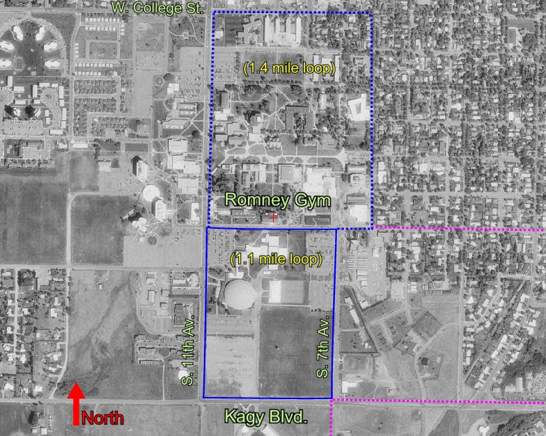
- 1.1 mile loop: Start at Romney Gym, then run on the sidewalk around the block to the south (bordered by Grant, 7th, Kagy, and 11th). Mostly flat course.
- 1.4 mile loop: Start at Romney Gym, then run on the sidewalk around the entire campus to the north (bordered by Grant, 6th, College, and 11th). Slight downhill heading north, slight uphill heading south.
- Other: The excellent MSU outdoor track is accessible just south of Kagy Blvd. on the east side of the football stadium at South 7th Street. The South Gallagator Trail is accessible off South 7th Street just south of the Museum of the Rockies.
MSU recreation members can also run (or walk) indoors on the elevated track in Shroyer Gym (12 laps/mile), or the Brick Breeden Fieldhouse track (8 laps/mile).
Peets Hill Loop: approximately 4.2 miles.
Click for larger version of
map, 238kB.
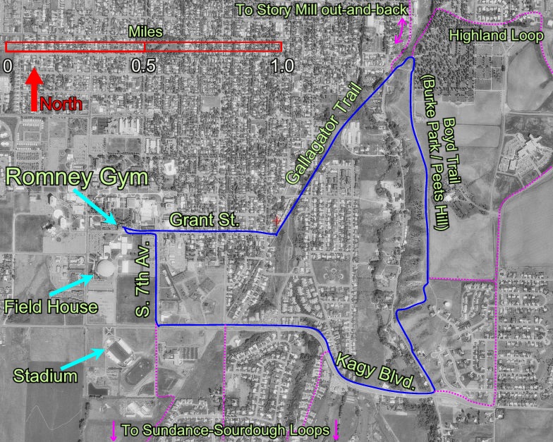
Clockwise description: 4910' elevation at Romney Gym. Slight downhill sidewalk on Grant St., cross Willson and look for Gallagator Trail through fence at dead end, turn left onto trail; slight downhill gravel on Gallagator Trail (to 4820'), cross Church Street and head up east then south on Burke Park trail(s). Continuous uphill (about 1 mile) on dirt/gravel to top of Peets Hill (5060' elev.), then downhill on dirt/gravel (Simkins Spur Trail) to Kagy. Turn right. Downhill sidewalk for 0.5 miles along Kagy, then gradual uphill to right turn onto S. 7th. Flat return on sidewalk to Romney.
Alternative loops and linkages: variety and extension. The Highland Loop begins the same, but cuts east through Lindley Park, continues east along E. Curtiss, and then joins the paved trail heading south up the hill along the west side of Highland Blvd. From the Highland trail you can either continue all the way to Kagy Blvd., or take the gravel cutoff segment up to the top of Peets Hill to rejoin the Peets Hill Loop route.
Story Mill
Spur Out and Back: approximately 6 miles.
Click for larger version of map,
235kB
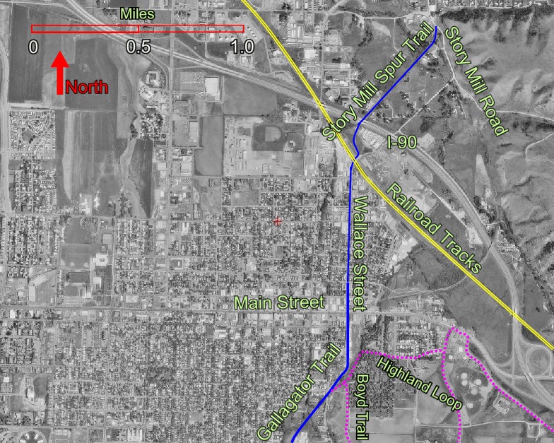
Note: photo above does not show the start of this route on the MSU campus. Description: 4910' elevation at Romney Gym. Slight downhill sidewalk on Grant St., cross Willson, and look for Gallagator Trail. Turn left. Slight downhill gravel on Gallagator Trail (to 4820'). Flat (about 1 mile) north on street/sidewalk along Wallace, crossing Main St., to railroad crossing (4760' elev.). Slight downhill on dirt/gravel to end of spur (4720'). Return via the same route, or make a small loop via Story Mill and North Wallace back to the railroad crossing.
Alternative loops and linkages: variety and extension. You can stay on the Gallagator Trail to where it meets the Bozeman Library, then cross Main Street at the Broadway intersection and run up Broadway to join the trails again at the old Bozeman train depot. From the end of the Story Mill Spur you can also continue north on Story Mill Rd., cross Bridger Canyon Drive, and join the East Gallatin Connector Trail to the East Gallatin Recreation Area. Another option that is longer and has more elevation gain is to proceed south on Story Mill Road a short distance before heading east up into the Story Hills area (privately owned, but the land owner allows recreational use unless signs indicate otherwise due to livestock operations underway).
Sundance-Sourdough Loop: approximately
5.0 miles.
Click for
larger version of map, 207kB.
NOTE: 1995 photo, so recent Sundance Springs subdivision, roads, and
trails are not depicted.
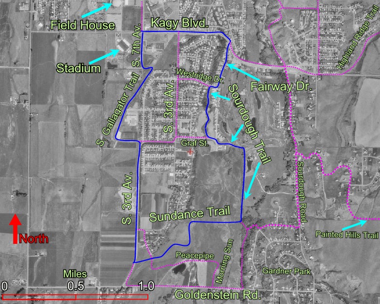
Clockwise description from 7th and Kagy (4910' elevation). Slight downhill sidewalk on Kagy to right turn onto Fairway. Slight uphill street on Fairway to Sourdough trailhead (right side just after city pumping station). Proceed south on gravel Sourdough Trail, bear left on sidewalk at Graf Street for 50 yards or so and look left for continuation of gravel Sourdough trail heading east through wood arch. Continue the very slight uphill Sourdough Trail for about a mile to the Sundance Trail junction (5000' elev.). Turn right. Flat gravel on Sundance trail to S. 3rd. Flat street and sidewalk north on 3rd, then flat gravel on Gallagator to S. 7th (paved) near the Stadium.
Alternative loops: for variety. Note that the Sourdough Trail has access points off Westridge, Graf, Goldenstein, and also into the Gardner Park neighborhood (lower right corner of map). There are also several new trail segments being constructed along the new greenways just west of the Sundance Springs neighborhood.
Painted Hills-Highland
Ridge Loop: approximately 9 miles.
Click for larger version of map, 205kB.
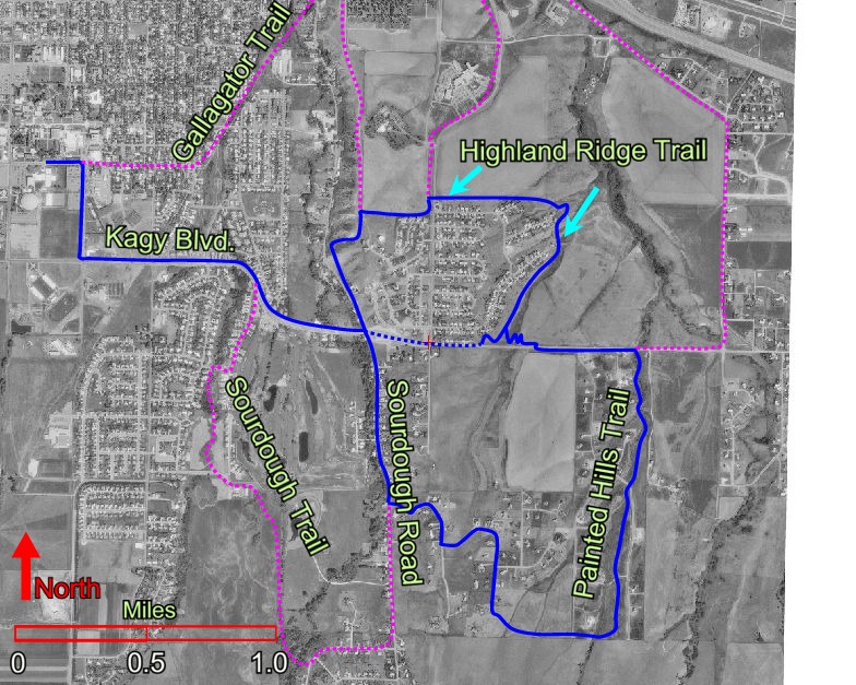
Clockwise description: From Romney Gym (4910' elev.), take Grant east to 7th, then south to Kagy. Take sidewalk east on Kagy to Church-Sourdough intersection (4920' elev.), then left onto dirt/gravel Simkins Spur Trail. Up to top of Peets Hill (5060' elev.), then east down to Highland Blvd. Look for trailhead slightly north across Highland Blvd (5000' elev.), then continue east on dirt/gravel Highland Ridge Trail to its low point (4920' elev.) and all the way around to the south. Just before reaching Kagy, take trail switchbacks up to the east, then cross Kagy (5000' elev.) and proceed east for about 0.5 mile on the dirt/gravel trail on the south side of Kagy, crossing Painted Hills Road and Bennett Drive. Join the Painted Hills Trail as it turns south up the draw. NOTE that the Painted Hills trail currently dead-ends, so leave the trail where it crosses the road (McGee Drive) and follow McGee west (right) to the intersection of Painted Hills Road, and turn south (left) and continue up Painted Hills Road until the fence line. Turn west and follow the trail in the unmarked pasture (5180') across to the Sourdough Ridge neighborhood. Follow paved roads as they wind down to Sourdough Road (4970' elev.). Run north along shoulder of Sourdough Road back to Kagy, and then return west on sidewalk back to the campus.
Cutoff Loop (dotted blue): sidewalk/street along Kagy connects to south end of Highland Ridge Trail.
Alternative loops: for variety. Numerous combinations of the routes listed here can be arranged. In 2014 new trails in the "Highland Glen" area provide good routes to the north and east of the Highland Ridge Trail. The route in the upper right corner can be reached by cutting east through Lindley Park, east along E. Curtiss, then cut through the parking lots east of Highland to reach Haggerty Lane and Bozeman Trail Rd., connecting from Main Street all the way around to Kagy. There are limited sidewalks on Haggerty and Bozeman Trail Road, so stay alert on the left shoulder (see and be seen by traffic).
Tayabeshockup Triple Tree Super Loop: approximately
12.2 miles.
Click for larger version of map, 263kB.
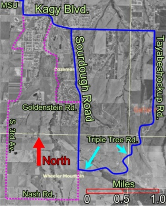
Clockwise description: From Romney Gym (4910' elev.), take Grant east to 7th, then south to Kagy. Take sidewalk east on Kagy all the way up the hill to the Highland Blvd. intersection (5012' elev.) and then continue east along the shoulder of Kagy for another 1.5 miles past the Painted Hills and Arrowleaf subdivisions (Kagy becomes Bozeman Trail Road). Turn right (south) on Tayabeshockup Road (paved, 5000' elev.) and proceed up the long, gradual incline for a couple miles to the scenic high point of the road within the Triple Tree subdivision (5420' elev.). Watch for elk and raptors along the way. Tayabeshockup becomes Triple Tree Road (paved), which bends west and south and gradually descends through the subdivision before reaching South Sourdough Road (5180' elev.). Turn right (north) and follow the shoulder of Sourdough Road all the way north to Kagy, then left on Kagy back to the campus (4910' elev.).
Be mindful of traffic along Kagy and especially along Sourdough: see and be seen!Alternative loops: After starting north at the junction of Triple Tree and Sourdough Road, go just as far as Goldenstein Road, then turn left (west) for a quarter mile or so to pick up the Sourdough Trail heading north (see Sundance-Sourdough description above). There are also routes from Triple Tree Road that cut back to Sourdough Road by way of Trooper Trail.
For a somewhat longer run you can turn south (left) on Sourdough Road and continue to Nash Road, turn right (west) on Nash and proceed all the way to South 3rd, then turn right (north) on South 3rd and follow it as it heads back to campus. Note that the Bozeman Creek/Sourdough trailhead is accessible south off Nash Road, and the Triple Tree hiking trail is accessible from Sourdough and from Triple Tree Road.
Big Sky Wind Drinkers
Local Bozeman running club and running event sponsor. BSWD holds weekly group fun runs on Wednesday evenings during the summer, monthly group runs during the winter, and a monthly newsletter year-round.Bridger Ridge Run: GPS track from 2015 sweep crew converted by Google Earth into a YouTube video.
Bridger Ridge Run: 2007 GPS tracking information, and a few photos from the 2005 Mt. Baldy Aid Station .
The "extended" BRR starting at Flathead Pass (2011): Info
An article on Running in Bozeman from the Bozeman Chronicle (15 April 2004) by Kellyn Brown.
Tom Hayes (retired Adjunct Instructor, MSU Math Department) with descriptions of several excellent trail runs all within about 30 minutes drive of Bozeman.
...and here is an article about Tom Hayes from the Bozeman Chronicle (15 Dec 2004) by Mike Kiefer.