
Infrared Cloud Imager Data
The Infrared Cloud Imager (ICI) is a ground-based thermal infrared imaging system that records downwelling emission in the thermal infrared 8-14 mm wavelength band. Atmospheric emission in this band is primarily from clouds and water vapor (minor gases include ozone and carbon dioxide). ICI images are calibrated in radiance units [W/(m2 sr)], but sometimes are displayed as brightness temperature for convenience. The clear-sky emitted radiance is calculated from measurements or estimates of the precipitable water vapor and subtracted from ICI sky images to obtain the residual radiance, which is processed to identify cloud presence, cloud type, cloud optical depth, etc.
Cloud statistics are calculated from these data over whatever temporal period the user desires. Applications for such data include climate studies and calculation of link-availability statistics for Earth-space optical communication links, etc.
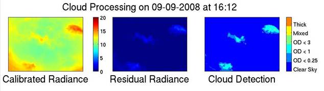
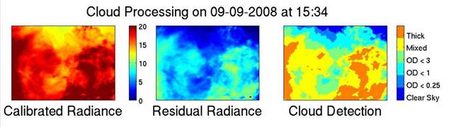
Example ICI-3 data (110° field of view) taken at Montana State University in Bozeman, Montana in Septembe 2008. In each 3-panel image the left-hand frame is a radiance sky image, the center frame is the residual radiance (after subtracting the clear-sky emission), and the right-hand frame is a cloud detection map. In this case the clouds are segregated by cloud optical depth (OD). The top 3-panel sequence shows scattered patches of thin cirrus, while the bottom sequence shows highly variable multi-level clouds.