
White Heat Tracks: Sled Travel Behavior In Avalanche Terrain
Contact Information
Email: [email protected]
Website: http://www.montana.edu/snowscience/sleds
Website: http://www.montana.edu/snowscience
Overview
This project aims to collect GPS location information and survey responses from backcountry riders / sledders to better understand what types of terrain decision we make. Our focus is on backcountry riders of all abilities and experience. You need not be an expert backcountry rider to participate in this research.
If you are a skier/boarder and want to participate - we have a separate project just for ski/board tracks ->www.montana.edu/snowscience/tracks
Participation
If you are interested in taking part in this project and sharing your GPX ski track information and responding to a few simple questions, then follow the easy steps below:
Please note: that steps 1 and 2 only need to be done once. Steps 3 to 5 can be done for every trip thereafter.
1. Complete a decision making survey (15-20 min)
To start, please complete decision making and demographics survey so that we know who you are and how you think about risk in the back country. You only need to do this survey once.
You can do this now, or after you have submitted some tracks. We will also send you an email about this later in the season.
Click on the link to start the survey: https://survey.eu.qualtrics.com/jfe/form/SV_0BRZRWigHHCkDgp
2. Download the application “SkiTracks” by CoreCoders or "Mountain Hub" to track your trips:
You are welcome to use any other tracking application you prefer, as long as you can email us your .GPX files.
Once you have downloaded and installed one of these applications on your GPS enabled smart phone or tablet, then you are ready to track and send us your GPX track data.
3. Track your trips.
Every time you go out for a backcountry trip, simply start your application and log your track.
While you are out, take photos of any key decision points – e.g. Did you see an avalanche and then decide to ski elsewhere (take a photo of the avalanche). Did you dig a snowpit and find out more information about the nature of the instability (take a photo of the snowpit). Or did you stop and discuss the route ahead (take a photo of the route ahead). Each photo is geo-referenced in both SkiTracks and MountainHub, so we can see where you were when you made this decision or discovered new information.
Once you have finished your trip, end by saving it. When you are back in cell phone or internet coverage, please send us your track and any photos. For SkiTracks, go into “History”, click on your track and share via email. In Mountain Hub, use the "share" icon and email us your track.
Please email your GPX file to [email protected]
4. Automatic reply
Once we receive your track (as a GPX file), we will send you an automatic email reply with a link to the post trip survey.
5. Complete a short (2-3 min), post-trip survey
Click on the link for the post trip survey from your smartphone, tablet or computer and complete the survey. We need you to complete this survey after every trip, so that we have both the track and the survey data. Together, these data will provide insights into decision making.
Or bookmark the website so you can easily navigate to the survey following every trip.
Confidentiality
We will not share your email address with anyone outside of the immediate research group. We will only use your email address to link you track information with your survey responses. We will also use your email address to contact you, should you win one of our spot prizes. Good luck!More information
If you want to learn more about our project aims and research questions and approaches, please visit our web pages and review our FAQs: www.montana.edu/snowscience/sleds
Frequently Asked Questions (FAQs)
Do I need to use Ski Tracks?
No. We will certainly accept GPX files from GPS units and / or other smart phone
apps. Please email these to the email address [email protected] as you will then receive an automatic reply with a link to the post trip survey.
We have suggested that people use the Ski Tracks application only because it makes
it easy for people to share their files with us - a standalone GPS or another app
works just as well for data collection, it's just that you need to connect / download
and then email the track (which is more work than sharing their track via the Ski
Tracks app).
As a side note - no one working on this project is affiliated with the developers
of Ski Tracks. This application is just one on the market that does most of what we
need it to for our project.
What about battery life?
If using Ski Tracks then to reduce power usage, you will be tracked using triangulation
from cell towers (if within range), and by GPS if out of range. Regardless of the
method of tracking, Ski Tracks will check battery life and stop tracking once the
level gets below a predefined threshold (20% by default). This ensures that you will
always have sufficient battery power to make emergency calls. You can adjust this
threshold to a lower value if you wish (e.g. 10%). Based on testing using a range
of phones, we have managed to track continuously for between 8 and 12 hours. Older
phones, with older batteries may manage less. You also need to keep your phone warm.
NEW INFORMATION: For users of iphones you can now use your GPS in "airplane mode" when you upgrade your operating system to iOS 9.
What about interference?
There has only been only a limited amount of work on this issue, however it does
seem that electronic devices (e.g. cell phones, radios, headlamps, MP3 players, GPSs,
etc.) can affect avalanche transceivers. The electronic devices affect the searching
beacon more than the transmitting beacon. Most manufactures of electronic equipment
do not mention possible interference between their electronics and avalanche transceivers.
However, a few diligent manufactures, such as Petzl, mention avalanche transceivers
specifically. This note that comes with the Petzl Tikka XP2 headlamp: "Warning, when
your lamp is lit and in close proximity to an avalanche beacon in receive (find) mode,
it can interfere with the operation of the beacon. In case of interference (indicated
by static noise from the beacon), move the beacon away from the lamp until the noise
stops, or switch off the lamp." In search mode, irregular readings and decreased range
can also be caused by other sources of electrical interference, such as power lines,
lightning, and electrical generating equipment. Based on one, very limited study (Barkhausen
2012), the distance between the electronic device and the avalanche transceiver seems
to be the key issue. Various avalanche transceiver manufacturers suggest 30cm (12
inches) to 50cm (20 inches) and based on the results from Barkhausen (2012) you should
attempt to keep them at least 40cm away from one another to minimize the impact of
the potential interference of your phone or GPS on your avalanche transceiver. Further
work is needed to examine issues around orientation / transceiver to device combinations
/ smart phone sending or receiving data etc etc. However in the meantime, we suggest
that the top pocket of your pack, or a thigh pocket on your pants might be a good
location for your phone or GPS.
Have other questions?
Please email us at [email protected] and we will respond to your questions. Happy riding and tracking!
Results To Date
Hendrikx, J. Johnson, J., and Shelly, C., 2016. Using GPS tracking to explore terrain preferences of heli-ski guides. Journal of Outdoor Recreation and Tourism, 13, 34-43.
Hendrikx, J and J. Johnson. 2016. Understanding global crowd sourcing data to examine travel behaviour in avalanche terrain. Proceedings of the 2016 International Snow Science Workshop, Breckenridge, Colorado.
Hendrikx, J and J. Johnson. 2016. Tracking snowmobilers to understand travel behaviour in avalanche terrain. Proceedings of the 2016 International Snow Science Workshop, Breckenridge, Colorado.
Hendrikx, J and J. Johnson. 2016. Heli-ski guide tracking for institutional memory and auditing. Proceedings of the 2016 International Snow Science Workshop, Breckenridge, Colorado.
Hendrikx, J., and Johnson, J., 2014. Using global crowd-sourced data to understand travel behavior in avalanche terrain. Proceedings of the International Snow Science Workshop, September 28 - October 3, 2014, Banff, Alberta, Canada. PAPER
Hendrikx, J., Shelly, C., and Johnson, J., 2014. Tracking heli-ski guides to understand decision making in avalanche terrain. Proceedings of the International Snow Science Workshop, September 28 - October 3, 2014, Banff, Alberta, Canada. PAPER / POSTER
Hendrikx, J., Johnson, J. and Southworth, E., 2013. Understanding Travel Behavior in Avalanche Terrain: A New Approach. Proceedings of the International Snow Science Workshop, October 7-11, 2013, Grenoble, France. PAPER / POSTER
This project has undergone MSU Human Subjects Review
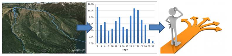
A schematic showing our data flow for this project, with an example of a GPS track
(shown in blue) overlain on Google Earth (Image courtesy of Google Earth); and example
output data from this track showing the distribution of slope angles traveled on this
days; and the resulting decision making process.